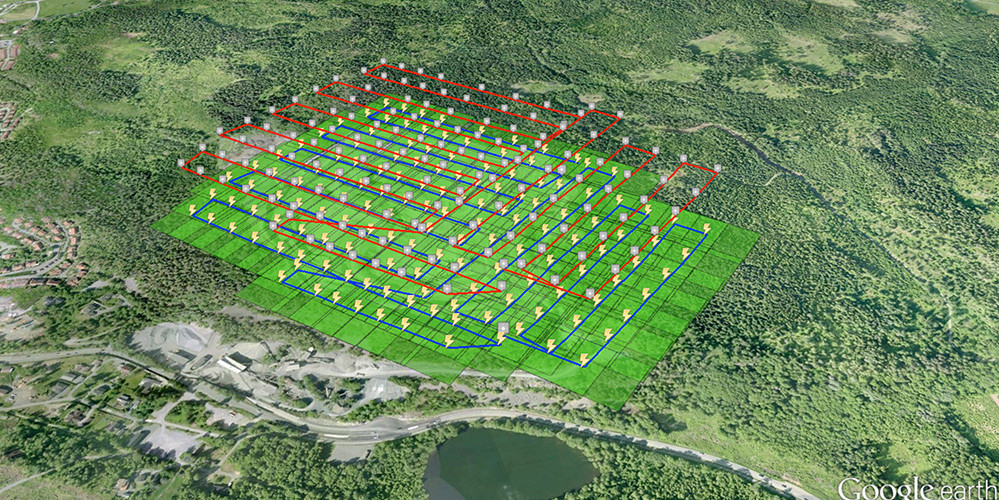
Drone mapping means flying a drone over an area in a planned grid, capturing hundreds or thousands of overlapping photos or LiDAR scans, and processing them into measurable maps and 3D models such as orthomosaics, elevation models and point clouds. A typical mapping drone covers a construction site or quarry in one flight, and with RTK positioning and ground control the results are accurate to a few centimetres. The key settings are flight height, which sets the resolution, and overlap: Pix4D recommends at least 75% overlap along the flight line and 60% between lines for most sites, and 85% or more over forests.
Looking for a map of where you can fly a drone? That is a different kind of drone map; see our no-fly zone guide.
Table of contents
How drone mapping works
Plan. Define the area, required resolution and accuracy, and set flight height, speed and overlap in a flight planning app.
Set control. Use RTK or PPK positioning on the drone and, where needed, ground control points and checkpoints.
Fly. The drone flies the grid automatically, taking photos or scanning at set intervals.
Process. Software matches the images, calculates their positions and builds a point cloud, surface model and orthomosaic.
Check and deliver. Accuracy is checked against checkpoints, and results are delivered as files or through a web platform.
Planning a mapping flight
| Setting | What it controls | Typical choice |
|---|---|---|
| Flight height | Resolution (ground sampling distance) and coverage per flight | Lower for detail, higher for large areas, within the 120 m open category limit |
| Front overlap | How much consecutive photos overlap along the line | At least 75%, 85% or more over vegetation |
| Side overlap | How much neighbouring flight lines overlap | At least 60%, 85% or more over vegetation |
| Camera angle | Map or 3D detail | Straight down for maps; oblique passes for buildings and facades |
| Light and weather | Image quality | Even light, low wind, no rain |
Ground sampling distance (GSD) is the size of one pixel on the ground. It equals sensor width times flight height, divided by focal length times image width. For a typical 4/3-inch mapping camera (17.3 mm sensor, 12.3 mm lens, 5,280 pixels wide), flying at 100 m gives a GSD of about 2.7 cm per pixel; halving the height halves the GSD. See our guide to drone weather limits for planning around conditions.
What you get from drone mapping
| Output | What it is | Used for |
|---|---|---|
| Orthomosaic | A distortion-free aerial map you can measure on | Site plans, progress, boundaries. See orthomosaic maps |
| Digital surface model (DSM) | Heights of everything, including buildings and trees | Volumes, obstacles, line of sight |
| Digital terrain model (DTM) | Bare ground heights | Contours, drainage, earthworks. See DSM vs DTM |
| Point cloud | Millions of 3D points | CAD, BIM and GIS |
| 3D mesh | A textured 3D model | Visualisation and inspection. See digital twins |
| Measurements and reports | Areas, distances, volumes, cut and fill | Stockpiles, earthworks, progress |
Accuracy
Without RTK or ground control. Maps look right but can be shifted by metres, which is fine for visual overviews.
With RTK or PPK. Positions are accurate to a few centimetres in many conditions, often enough for progress mapping.
With ground control points. The most reliable route to survey-grade results. See our guide to ground control points.
Always check. Measure independent checkpoints to prove the accuracy of each survey.
Cameras vs LiDAR
Photogrammetry with a camera is cheaper and gives realistic colour maps, so it suits open sites, stockpiles and buildings. LiDAR measures the ground under vegetation and captures thin objects such as power lines. See our comparison of photogrammetry vs LiDAR and RGB vs multispectral sensors for agriculture.
Drone mapping software
Cloud platforms such as DroneDeploy and Pix4Dcloud are quick and easy to share; desktop software such as Pix4Dmapper, Agisoft Metashape and DJI Terra gives more control. See our guide to drone data processing and our DroneDeploy review.
What drone mapping is used for
Construction. Weekly progress maps, earthworks and site logistics. For Winthrop's 48 MW data centre build in Finland, Flyby Guys flew weekly mapping flights with RTK and shared the maps through DroneDeploy. See drones in construction.
Parks and public spaces. For Stara, Helsinki City Construction Services, Flyby Guys mapped one of Helsinki's largest parks in 3D to plan improvements. See urban planning with drones.
Mining and quarries. Stockpile volumes and pit surveys. See drones for mining.
Agriculture. Field maps and crop health. See drones for agriculture.
Energy and infrastructure. Solar plants, power line corridors and railways. See powerline inspection.
Rules for mapping flights
Small mapping jobs over open, rural land can often be flown in the EU open category. Mapping in towns, near people, over industrial sites or beyond visual line of sight usually needs the specific category and an operational authorisation. See our guides to EU drone regulations and SORA, and check airspace with our no-fly zone guide.
Frequently asked questions
What is drone mapping?
Flying a drone in a planned pattern to capture overlapping images or scans, then processing them into measurable maps and 3D models.
How accurate is drone mapping?
With RTK and ground control points, typically a few centimetres. Without them, maps can be shifted by metres. Always check against independent checkpoints.
What overlap do I need for drone mapping?
Pix4D recommends at least 75% front overlap and 60% side overlap for most sites, and 85% or more over forests and dense vegetation.
How high should I fly for drone mapping?
As low as needed for the required resolution. For a typical 4/3-inch mapping camera, 100 m gives about 2.7 cm per pixel.
What is the difference between drone mapping and drone surveying?
Mapping produces maps and models; surveying adds verified accuracy in a defined coordinate system, usually with ground control and checkpoints.


